Reaching great heights for even greater sights
With temperatures dropping as winter approaches, the highest points of Cromer Ridge in north Norfolk are a reminder of a time when two-thirds of the country was buried beneath thick ice sheets
Ask anyone in the country for a fact about Norfolk and the chances are they’ll tell you it’s flat. According to the 1930 play Private Lives by Noel Coward, it is “very flat.” For those of us familiar with the county, however, we know it’s not strictly true. Although the west of the county borders the low-lying Fens, north Norfolk also boasts the highest point in the whole of East Anglia.
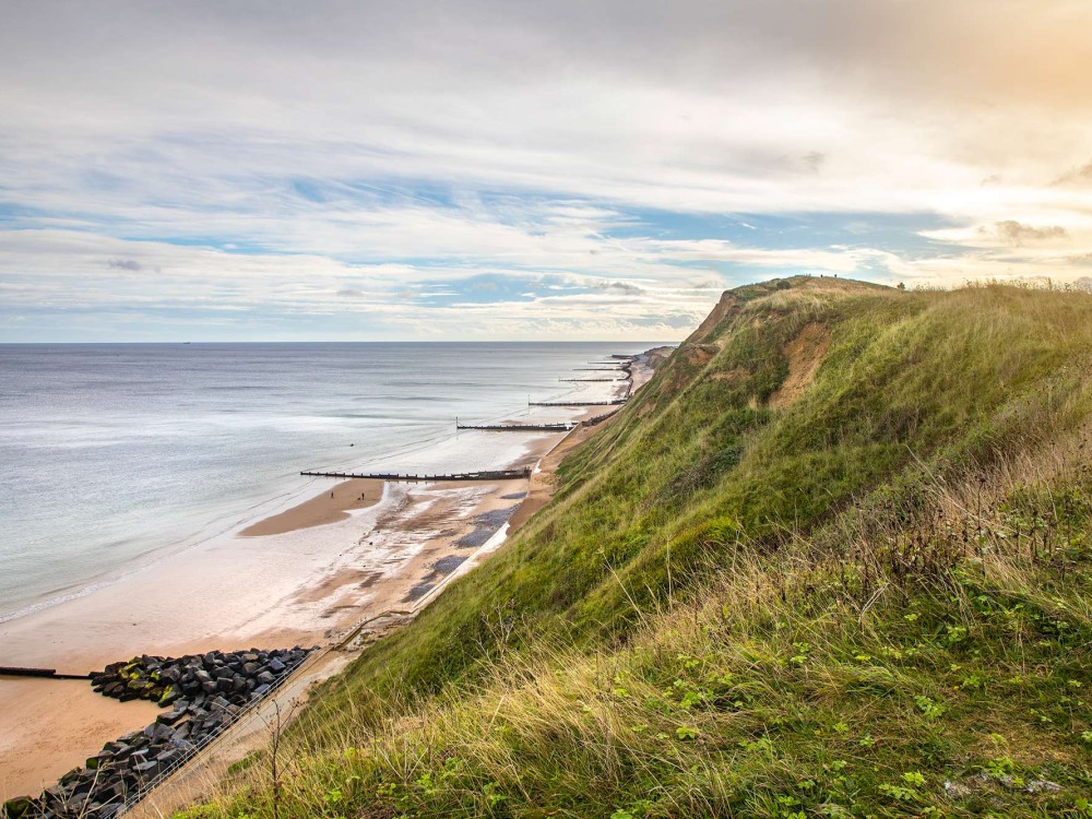
Beacon Hill rises 103m above sea level, offering beautiful views out to sea as the pinnacle of the 8.7-mile-long Cromer Ridge. What we see today, however, wasn’t there during the formation of the ridge – because at the time Norfolk was buried beneath a 3-mile-thick glacier.
Around 480,000 years ago Britain was in the midst of the Anglian ice age, the largest glaciation that affected the country in terms of size. Reaching across the west coast of Ireland and across the North Sea all the way up to Norway, the British Ice sheet also travelled south to Oxfordshire and Essex. It even diverted the River Thames – which originally flowed north to the Wash – to its current position in London.
“You can imagine the scene during the Anglian glaciation when north Norfolk resembled the edge of the modern Greenland icesheet,” says Martin Warren, local geologist and ex-curator for Cromer’s and Walsingham’s museums. He’s devoted much time to studying the formation of Cromer Ridge, and the results of his research are compiled on his website at www.northfolk.org.uk.
“The glacier stretched away to the north and over the horizon,” he says, “a blanket of ice in place of the North Sea.”
When the glacier began to melt, the sediment and till it was carrying was left behind. These deposits formed the bumps and hills that make up

Cromer Ridge, which is what we see along the north Norfolk coast today. And the geography of the ridge is just as interesting now as it was during its formative years.
“It has a significant impact on the landscape and climate,” says Martin. “It consists of a lot of woodland, though formerly it was heathland. The trees provide a barrier from the sea air, so nearby coastal towns have different microclimates compared to those south of the ridge, having fewer frosts and less snow, but more fog and mist.”
The mix of woodland and heathland, along with the stretching vistas, are appealing sights for people trekking along the ridge. Various hills act as waypoints for visitors, including Beeston Bump just east of Sheringham, which has been described as looking like a cross-section of a hill, as its seaward side has completely eroded away.
The history around Beeston Bump extends as far back as Saxon times when Beeston Regis was used for iron works. The sites were excavated in the 1850s and contained debris from metal working processes, including iron cinder and pottery sherds. RAF aerial photography in 1946 gave experts a better indication of how far across Beeston Regis the pits extended, and since then even more sites have been unearthed. Along Cromer Ridge, you can still find bits of iron and limonite nodules, and even the viewpoint compass pillar on Beeston Bump has iron slag incorporated into the masonry.
Similarly, there’s more to Beacon Hill – located a gentle hike 2 miles further inland from Beeston Bump – than lovely views and the accolade of being the highest point in East Anglia.
Around the hill, evidence of earthworks tells us there was once a coastal signal station there, hence the name ‘Beacon’ Hill. A report in 1324 mentions a watch being kept there, and during the Spanish Armada through to 1608 regular repairs were made to the station. Records from the Norfolk Quarter Sessions have also been found detailing money being raised in the 1650s for maintenance of a beacon.
By the end of the 18th century, though, it appears the signal station was no longer in use. William Faden, Royal Geographer to King George III, published his Map of Norfolk in 1797, in which he calls Beacon Hill “The Old Beacon” or “Watchtower.”
At the turn of the 19th century, the hill was coined Roman Camp, although not because evidence of Roman occupation had been discovered. The earthworks left from the signal station inspired local cab drivers of horse-drawn carriages to refer to the area as Roman Camp, hoping the historical name would attract tourists and bring more fares to their businesses. Even now, we don’t know if the Romans set up a camp there, but regardless, the name has stuck.
The upcoming winter may not be an appealing time for some to want to walk through the wild heathland, lofty hills, and thick woodland around Cromer Ridge, but if the breathtaking views don’t lift your mood, consider this: at least you’re not hiking through a freezing polar desert with giant mammoths stepping over you.


