A different perspective on the history of Norfolk
Don’t think you’re familiar with our local landscape until you’ve seen it from the air, especially when you can see how it looked many years ago and how our towns and countryside have changed
If you look at the landscape intelligently, you can learn an enormous amount about where we’ve come from - and when you take a birds-eye view you can learn even more.
At the popular Gressenhall Farm & Workhouse museum just outside Dereham are housed over 21,500 aerial photographs taken by the Norfolk Archaeological Unit. All but 15 were taken by the remarkable Derek Edwards - who founded the Norfolk Air Photo Library in 1974 and is now considered to be one of the most significant collections in the country, with almost 100,000 images of Norfolk taken between 1915 and the present day.
There used to be a time when Enclosure Award and estate maps were the most important historic documents in terms of documenting our changing world, but aerial photography (which wasn’t even possible until the start of the of the 20th century) is rapidly outpacing them.
Since the programme began, our understanding of how Norfolk used to look has changed completely. Until 1974 we only knew of 196 Bronze Age burial mounds (or ‘ring ditches’) but within 12 years that number had risen to almost 1,000.
Of course, we’ve always managed to change our landscape to suit our needs.
Over seven million visitors enjoy the natural wonders of the Norfolk Broads every year (they’re home to 25% of the UK’s rarest species) but very few understand that ‘natural’ is a relative term - and that the beautiful waterways they spend their holidays on were actually created (unintentionally, by the way) by over 200 years of intensive peat digging.
This image over Holkham over the page was taken in May 1978. Awaiting to be confirmed by excavation, its elevated position over the surrounding marshes on the estate suggest that this is all that remains of an Iron Age fort - and the vertical line running towards the pine trees is believed to be the end of an old sand spit similar to those found at Scolt Head and Blakeney Point. The landscape changed enormously in the space of only 200 years, and the sea originally reached as far as the coast road through Holkham. The general layout and position of the fort fits uncannily well with the description by the great historical author Tacitus of a fort in a similar position that invading Romans stormed in 47AD - although that’s yet to be proved conclusively.

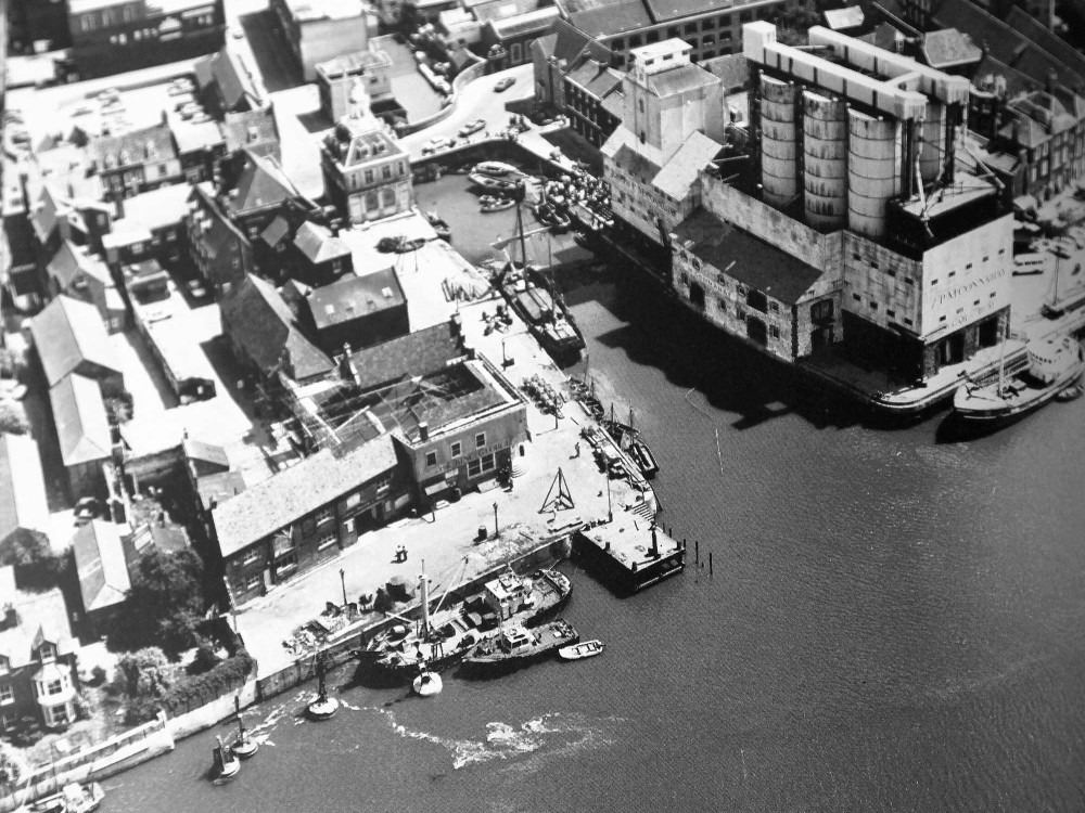
This view of the Purfleet in King’s Lynn on the was taken in 1985 and contains a host of interesting details that have now been lost to time. Until the 19th century this had been an important waterway lined with wharves along the river. Connecting to an important sewer further upstream, it was frequently blocked until a film crew arrived to clear it and turn it into part of New York for the film Revolution.
People familiar with the town will be fascinated by the massive grain silos on the right towering over Bank House, and they were already derelict by the time this photograph was taken. No trace of them remains today.


ABOVE: The Norfolk Archaeological Unit and Norfolk Air Photo Library have ammassed an incredible archive of over 100,000 images documenting the changing face of the county from the air - including the one above of the Purfleet in King’s Lynn (left) compared by a recent photo by KL magazine photographer Ian Ward (right).
One of the most interesting photographs in the collection is this view over Dereham taken in June 1976 featured opposite. It dramatically shows why peace returned to the town less than two years later with the opening of the A47 Dereham by-pass.
The market town owed much of its size and commercial importance due to it being in the centre of Norfolk and astride the main road leading from Great Yarmouth and through Norwich, to King’s Lynn and from there to the Midlands and the North.
By the mid-1970s around 1,200 heavy goods trucks and almost 7,000 cars were squeezing through Dereham’s narrow streets every single day, causing congestion and dangers for both residents and drivers.
Calls to alleviate the problem started in the 1950s and were finally approved 20 years later. The seven-mile route was built on part of a disused railway line, cost £5million to build, and was opened to traffic on the morning of March 20th 1978.
It’s an extraordinary and very different way of looking at Norfolk, and it’s one recently taken up with the National Mapping Project (NMP) - an initiative by English Heritage to record and preserve the history of the whole country through the use of aerial photography.
Since 2001 the Norfolk NMP has mapped approximately 39% of Norfolk, recording almost 9,000 archaeological sites - around 50% of which had never been recorded before - using a variety of different sources including the National Monuments Record collection in Swindon, the archive of the Norfolk Air Photograph Library, and photography from Norfolk County Council. More details of the project can be found at www.heritage.norfolk.gov.uk/nmp
A fully detailed catalogue of the digital images in the Norfolk Air Photograph Library is available here, and jpeg images are available by request free of charge.
